Somewhere over the rainbow...
- One Girl and a Van
- Mar 29, 2022
- 17 min read
Updated: Apr 5, 2022
Vanlife Road Trip - Part 14: NC500 West Coast - Durness to Ullapool
25 September - 4 October 2021

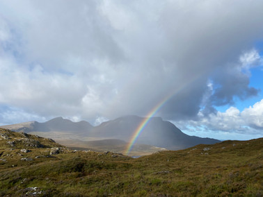
Rainbows in Scotland's Highlands are pretty epic... travelling around the north west of Scotland, we were lucky enough to see some stunning rainbows. They spanned epic mountain ranges, rivers and Lochs; the rainbow sometimes creating the perfect picture you would paint as a child. If only we could have located the pot of gold... However, rainbows equalled some pretty horrendous wet weather; but that's what raincoats are for!
After an amazing few days chilling and exploring the local beaches around Durness, we headed off down the Kyle of Durness and in to the mountains. The views were as breath taking as usual, in fact, we were starting to feel a bit 'epic' viewed out... 'Oh look, another waterfall and amazeballs view'!! Yawn!!
The road weaved on through the moorland, with mountains rising from the ferns, high in to the sky. Water rushed off the hills, creating plummeting cascades just out of reach, and the road looked to stretch on forever. A sharp right turn in the middle of nowhere, took us off the main road and on to a winding single track lane that ran along the shores of Loch Inchard, through farmland and tiny hamlets, past scattered lochans, and down to a dead end road and the stunning Oldshoremore Beach.
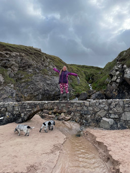
Yup that's right... another sandy empty beach! We walked along the gorgeous white sand beach, clambered up on to a rocky outcrop and stared out over the sea towards Ireland. The wind was blowing pretty fierce, so we retreated back to the comfort of the vans and headed to our park up for the night, just a little further back up the road, in the gorgeous small remote crofting hamlet of Blairmore. The estate of Sandwood contains eight islands, a saltwater lagoon, a freshwater Loch, and it lies within a Special Area of Conservation. Managed by the John Muir Trust, the area is so well maintained and the facilities and footpaths are beyond expectation. If only other parts of the UK would follow this excellent example of creating a welcoming and well looked after place of beauty for all to enjoy, but with facilities in place to help fight rubbish, waste disposal and disrespect of the local community. Here locals and tourists happily enjoy this glorious place together. Donations were asked for, and I happily left one, but equally I would have been happy with a fixed fee for the use of the car park for two nights and being able to fill up my water etc too; plus the location was worth far more.
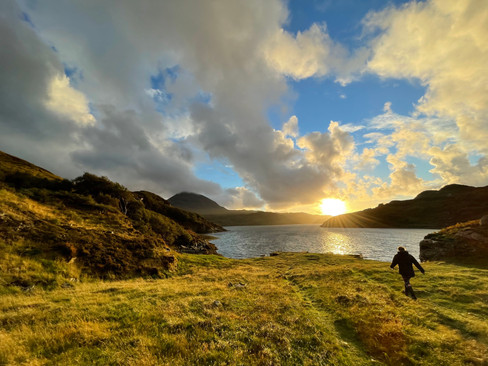
Once settled in, we took a stroll up a nearby hill to watch the sun set. The light was fantastic and despite the wind, the weather appeared to be looking good for our long hike the next day to Sandwood Bay, just 11 miles from Cape Wrath and one of the most remote beaches in the UK - and according to George, the most stunning!

We woke early, packed the bags and it started to rain! So, camping on the beach was abandoned and instead we chilled in the van until later in the day when the rain cleared and a little stroll down to Sheigra Bay was had... Another beautiful little bay, with a friendly seal wanting to say 'hi' and even a pretty £5 a night campsite (I say campsite, it's an uneven field on the dunes). We strolled down, checked out the 'site', to decide whether to move or stay put, said hello to the seal, before mooching back to the vans hoping for better weather in the morning.

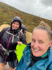
Well, it was still raining but we decided to crack on... the beach camp had already been aborted but a nice 4.5mile walk to Sandwood Bay would surely be achievable in a bit of drizzle. We had swim stuff, a picnic, warm drinks, a belly board and sandboard; so we were covered for all eventualities. The dogs were raring to go, and so off we went.
The walk is along a lovely well maintained track, that runs through a Dartmoor style landscape, but with lots of Lochans instead of bogs! Just under a mile in, I was having a sense of humour failure, the weather was getting worst (er!) and it was down to a game of Rock, Paper, Scissors, as to whether this hike should also be aborted. I won (it took a while - I could easily have been warm in the van in the amount of time it took George to get the rules correct!) and we retreated back the way we had come, to the warmth of the van, a cup of tea and dry clothes. I was absolutely gutted as I was so excited to get to see Sandwood Bay, but there would be other opportunities to return and camp on 'the best beach in the UK'.
We'd spent two nights at Blairmore, so decided it was time to move on. We headed back along the picturesque road, retracing our steps from a few days earlier, until we were once again on the 'main' road to Ullapool. This section of driving is some of the most stunning we had experienced to date on this trip around Scotland. Mountains filled the horizon, waterfalls cascaded from the hills through the fern clad valleys, tumbling to meet the cold fast flowing rivers that ran alongside the road. We drove over narrow old stone bridges and past great Lochs of reflective water; deer could be seen grazing and birds of prey were dancing on the thermals. It was just beautiful and despite the horrendous weather, I fell more in love with Scotland.

After a long but epic drive we arrived at Kylesku Bridge. Now, if you like architecture and clever engineering; this bridge is for you. It is absolutely stunning, with it's 276m curved design linking Kylesku with Kylestrome. The bridge, opened in 1984, links the highlands with central Scotland and is the only way south unless you head back up to Laxford Bridge and down to Lairg. Before the bridge existed, boats had been ferrying people and stock over this body of water since the early 1800s. Initially a simple rowing boat was in place to transport farmers over as their cattle swam across the Loch.
There is a carpark either side of the bridge, and we pulled in to the large one on the northern side as the most perfect rainbow appeared, arching from Kylesku to Kylestrome over the bridge. It was so clear, like out of a painting and I almost jumped from the bridge to go retrieve the pot of gold at it's foot!

After the rain had passed, we headed out for a stroll over the bridge to see the views up Loch Gleann Dubh. The wind was insane and as the bridge is so exposed, it was a struggle to walk over it! My mouth could speak without me trying to talk, as the wind whipped around my cheeks causing a funny fish face and associated strange gurgling noise! The views on the other side did not disappoint, and with the sun starting to set, the colours were even more breath taking.
From every point there are things to see and so much to take in. Three Lochs merge beneath the bridge, making their way out to sea; and if you headed up one of them you would find the highest waterfall in Britain standing at the tip of Loch Beag. Across the Loch you can see the domed mass of Quinag; on clear days I'd imagine even the pointy peak of Suilven may be visible.
We stayed here the night, enjoying the changing light over the water, listening for the sounds of wildlife. It felt like a special place; no reasons why, I couldn't find any tales telling me of any mystical relationships in the area, but there was something peaceful and rather spiritual about this spot.

We'd had a melt down (I say we, I mean me!) the previous night on discovering we were out of gas, apparently we were drinking too much tea, so it was decided I would make the dash to Ullapool to get some along with a basic food shop. We hopped in the vans and crossed the bridge - fortunately the wind had died down - and continued the drive through this glorious landscape. Just up the hill I pulled in to view the Maldie Burn hydro plant; I couldn't see much from the road, but the waterfall was in full spate and absolutely stunning. My phone pinged in to life after days with no reception, and sad news was waiting on my voicemail. I picked up my messages, and was so saddened to hear that my cousin Rob had lost his fight with cancer at a young age, and so I stood for a few minutes in this beautiful place and said a little prayer for him and his loved ones left behind. The sun broke through the clouds, the vast Scottish Highlands stretching out in front of me and I reflected on how very lucky I am to be living this life, and how very short life can be...
The road cut through the rugged mountainous landscape, beginning to wind up steeper passes, and the epic Assynt peninsula stretched out before us, just waiting for us to explore it's famous mountains and rugged coastline.
We pulled in to a carpark beneath Quinag, where I abandoned George and plodded on the remaining 28miles to the great suburban (well we had been in the wild for days!) town of Ullapool. Now, 28miles in the north of Scotland is like driving over Dartmoor; it takes hours! Two hours later I had seen more unbelievable scenery, got stuck behind a convoy of vintage cars, waved at some hairy bikers, and had finally arrived in Ullapool. Fortunately I had called ahead, so gas bottles were awaiting my collection and I topped up with diesel whilst there, just in case (apparently the UK had been hit with another fuel shortage whilst we were off grid and oblivious to the comings and goings of the outside world). A quick Tesco shop, toilet visit and call to Dad and I was back on the road to the wilderness...
On the way back I stopped for a slice of cake and coffee (I was missing real coffee) and admired some more picture postcard views at Loch Assynt.

Gas fitted, tea brewed and dinner eaten; we pulled on our walking boots for a mooch around Quinag. We didn't venture too far up the mountain, as we had a big adventure scheduled the next day, but the walk we did was wonderful and perfect for the dogs to stretch their little legs after a day in the van. As for the views? Well...
An early night ensued, followed by a super early start. We were planning to hike to Eas a' Chual Aluinn; Britain's highest waterfall. We moved my van to a car park further down the pass which gave easier access to the start point for our hike, and clambered back in to bed for an hour!
Being professional waterfall hunters (as you'll know from previous blogs) we were soon kitted up and ready to head out on our mini adventure to track down this fall. The route, according to various online descriptions, was a 'pleasant, easy access walk to Britain's highest waterfall...taking just over 2 hours'. Ummmm; NO IT WAS NOT! Within 500 meters, we were up to our shins in bogs, hunting for a way to proceed without sinking at the very start of our 'little hike'. We eventually made our way through the initial damp ground to the very pretty Wailing Widow waterfall that cascades from Loch na Gainmhich to Allt Chranaidh and on to Loch Glencoul and Kylesku. If the weather had been horrendous, I may have been tempted to say 'waterfall seen - tick', but that's not what pro waterfall hunters do; so on we plodded through the bog, crossing the stepping stones just above Allt Chranaidh and to the shores of Loch na Gainmhich.
Here, any semblance of path vanished and so I referred to my map and did a classic Emma approach to hiking (also riding, boarding and most outdoor activities), stating, 'just follow me'. And so we ploughed our way across steep, wet moorland to eventually join back up with the path that had vanished in to the boggy depths of Assynt.
Max had already had enough of the walking, so got himself a little lift!
From here, the path took us up the side of Allt Loch Bealach a'Bhuirich to the stunning Loch Bealach a'Bhuirich. It was rocky, slippery and hard going, and we ascended 270meters in just over a kilometre. But the views were worth it. The rain started to fall but it was a light drizzle, and so we found a sheltered spot for a little coffee stop.
On we climbed until the views opened up in front of us and we were at the highest point of the walk. Mountain ranges, Lochans and waterfalls filled the horizon and a rainbow appeared, creating an archway ahead, encouraging us to keep going.

From here we thought it would get easier (I mean it was downhill) but no, it got harder and it was like crossing the Arctic pack ice, but wetter and not as cold! Up and down we scrambled, and what was only a few hundred meters felt like many many miles... We were exhausted, wet, and hungry, and still not at the waterfall.
Finally, after traversing yet another peat mound, we were back on solid (ish) ground and the roar of the falls could be heard on the wind. We scrambled down to the edge of the cliff to see the falls as they plummeted 200m to the river below. Unfortunately, you can't see much of the fall from above as the drop is so sheer, but at certain times of the year you can travel by boat to it's foot and gaze up at this magnificent sight. I cursed George for not having her drone with her, but after literally hanging over the edge to try and get a better view, and having mini heart attacks every time a dog came a little too close; we backed off, found a cosy spot to perch, had our lunch in the drizzle, and enjoyed the sights and sounds of this spectacular location.
The return journey was just as challenging, and after over 6 hours of walking, and with exceptionally wet boots, we made it back to the van for a well deserved cup of tea.
We had an amazing day on this hike, and although the waterfall views were a little disappointing, the general views and majesty of the area were totally worth it. But make sure you take a map, know how to use a map, take food and water, and be prepared for a proper hike and not a little 6 mile stroll. Oh, and do not bother taking your swimming costume as there's nowhere to swim!
We stayed the night back under Quinag, and the next morning headed towards Stoer. The drive took in more amazing scenery, with the views from the top of the pass looking out over Loch Assynt especially stunning. The road to Clachtoll Beach passed so many beautiful Lochans, each reflecting the surrounding colourful landscape on it's surface.
After stopping at Clachtoll to do some admin chores (toilet emptying!) and to stretch our legs on the quaint sandy beach, we mooched on up the windy road to Stoer lighthouse. The final approach to the lighthouse was along an exposed single track lane, which gave extensive views out to sea, with Harris and Lewis stretching out in the distance.
The little car park was quite busy and rain clouds hung dark and moody in the distance threatening rain; so we grabbed our coats, tucked the boys up in the dry and decided to hot foot the 4 mile round trip to the Old Man of Stoer. The first half a mile wasn't too bad; the sun was out, however, the wind was picking up, and the views back towards the lighthouse were awesome. We were following the cliff path and it suddenly looked a little precarious as if the whole ground may subside in to the sea below, so we decided to head a little further in land away from the cliffs! The route was boggy and well trodden by stock, but we soon came to a better path heading up towards Síthean Mòr and the trig point that sat at this little mounds summit.
However, 500m from the summit, the heavens opened, the cattle made a dash for shelter and we, exposed in the middle of open moorland, were drenched! The clag descended and the way towards our destination looked bleak. With just over 1500m to go, we had a quick discussion on how much wetter we wanted to get, and decided once again to abort the mission... wet and disheartened we headed back the most direct and easy route towards the vans.
We got changed and dry, had a cuppa (cure for all), and just watched the storm pass. An hour later the skies were clear again.. typical!
We drove back through the little villages and past the Lochans to Lochinver, where we broke right and headed down to Inverkirkaig. Another epic drive, but a severe lack of places to pull in for the night. The route weaved through beautiful hamlets, and literally along the shores of Loch Kirkaig and Loch an Èisg Brachaidh. I wish we could have stopped around here as the views and landscape were from another world and it would be amazing to walk some of the footpaths around this coastline and explore the hidden coves and many islands scattered around Enard Bay.
The road started to head back in land through a landscape of small hillocks and tree lined burns; the moorland feeling more and more remote the further we explored. The large dominating mound of Cùl Mòr and the rugged peaks of Stac Pollaidh were pulling us closer, and soon we were descending off of the open moors to the fern lined Lochs below Badagyle. Here we could head left towards Ullapool or right through little villages to an eventual dead end but with the promise of a little sandy cove off the beaten track. Right we went... By the time we reached the view point overlooking the tiny hamlet of Achnahaird it was getting late and dark. We could stop here looking down the inlet to the beach, or drive through Achnahaird to a little beach car park.
It was a pretty drive and our headlights bounced off the local sheep's eyes as we bumped our way down the track to the beach car park. It was small but empty and so we parked out of the way, taking up as little space as possible (hard in two large vans), and settled in for the night.
The next morning we were rewarded with the perfect view... bright turquoise sea, towering mountains and vast blue skies.

There was a short walk up to the beach, so we decided to take the boys for a stroll. It was cold, the wind bitter, and we weren't feeling the love for a swim, but I'll certainly be returning here another day to swim and SUP these stunningly clear waters.
We left Achnahaird Beach late afternoon and made our way back past the Lochs to the foot of Stac Pollaidh. We wanted to get there at a reasonable hour to blag a parking spot for the night and the next day, as we knew it would get busy if the dry weather continued.
We woke early to a mizzly start, the intention to get cracking climbing this peak before the hoards arrived.

Stac Pollaidh stands at 612m and is a gorgeous mountain to hike. There's a fabulous 4.5km circular walk that starts from the car park and takes advantage of the mountain's immense view point at the summit between it's twin towering peaks. For those without a head for heights, you can follow the circular route around the mountains lower slopes and enjoy the wonderous views without the hairy scramble to the summit ridge.
The first section of the walk consists of a series of tall steps; which led to a few stops to look back and admire the views (also known as catching one's breath!) over the vans to the lovely Loch Lurgainn with its tiny islands, and Sgòrr Tuath and Ben More Coigach beyond. After the steps you enter open shrub land and a gravel path leads you towards a deer fence where you see the return path to the left. Ahead, the mighty peak rises up like a volcano amongst the barren landscape.

We were just over 300m up and the path was starting to contour around the mountain; the views opening up to the east over the glistening Lochs to Cùl Mòr, Suilven and Canisp were immense. The sun was shining, the day was heating up, and it was time for a sit down and a cuppa.
Now the view over Assynt, that I just mentioned, is beyond description. I don't have the vocabulary to describe its beauty and unfortunately no photo or video will ever do it justice. All I can say is that it took my breath away and I had tears in my eyes. It was so stunning I had to send a picture right there and then to my Mum to share the sheer glory of the place.
So, if you are in this area on your travels, climb Stac Pollaidh, even just to the foot of the mountain on the eastern flank... you will not be disappointed.


As we followed the track around, the views became even more spectacular; the late summer light turning the Lochs a deep sapphire blue, the Torridonian sandstone peaks appearing to be sculpted in to mountains and plonked amongst the landscape of moorland grasses and water.

At 430m, the path splits and here you can continue to contour around or take the steep rocky path up the mountain. The path becomes far rockier from here and after a short section of almost stepping stones, it becomes a sharp, steep scramble up the final 40m to the col. It's a hands on climb up, and exposed in places, the wind whipping across our faces and the dogs ears flapping in the breeze. After a bit of huffing and puffing we were at the top and the views stretched out in all directions, and boy were they worth the exertion.
Here, you can walk out on to a fabulous floating ridge, jutting out to the south west, the views stretching far across Coigach.

If you want to get higher, the peak to the east is a simple scramble, just a few meters high. It is exposed though, so caution must be taken, and if too windy, stick to the col. To get to the true summit and the 612m western peak, requires a technical scramble and adequate kit, and should not be attempted without the appropriate skills and experience.

It was really bitter in the wind, so we started our descent, taking the western route back down the mountain. The terrain back down was harder than the ascent, with slippery rocks and boggy sections, making the going tough and a lot slower.
My back was beginning to ache, so I whipped out my poles to help my little Hobbit legs down the pass and give me some much needed support over this tricky section. If you've non Hobbit legs and are fit and less injured than me, you'll be fine!
As we headed down, the views looked across what appeared to be water logged plains (in fact, loads of tiny Lochs, Lochans and waterways glistening in the sun) towards Enard Bay and it's array of little islands floating amid the bright blue sea.
Back at the vans, we packed our kit away ready to head off to Ardmair and our little campsite we had booked for the next two nights.
Just preparing to head off, a hobbling bleeding George appeared at my door... 'what on earth have you done you idiot?', I asked in my compassionate and caring way. Well, it transpired that the fool had slipped out of the back of her van in her Crocs (blooming dangerous footwear if you ask me - there's a reason I don't endorse them!) and ripped the tip of her toe off. Yes, of course I rolled my eyes! So nurse Emma to the rescue; I bathed the wound (I bet that hurt), cleaned it up (lots of dirt in it requiring scrubbing), applied stitches, bandaged her up and told her to stop wearing Crocs. Friendly back slap applied in the, 'you'll survive' vain; and it was time to hit the road - you don't need your toe to drive!!

A delicate (well someone only had one foot) drive took us through the southern tip of the North West Highlands Geopark and the last of beautiful Assynt, before we started to descend in to Ardmair and the mountains reverted back to views of the sea; looking out over Loch Kanaird, the Isle of Martin and the jutting peninsula of Cailleach Head.

We spent two days chilling and doing laundry at the campsite in Ardmair, before we headed to Ullapool for a bit of retail therapy - well Tesco!
Ullapool is a fabulous little town, with plenty to see and do. We strolled around the town, peered in the shop windows, sat and people watched, looked out across Loch Broom at the boats coming and going, and ate some delicious seafood from the Seafood Shack.
The sun shone down on us as we sat stuffing our faces with the most amazing langoustines and tempura haddock wraps, feeling like we were on holiday - but we were; one long epic holiday of adventures and happiness...
Join us next time as we leave the NC500 and head to Oban... chasing more waterfalls, hunting for Nessie, mountain biking on an actual mountain, and sharing more laughs and adventures on route.
Thank you as always for reading. If you'd like to watch the videos that accompany this section of our travels, please visit George's blog, 2Born2Travel or click the links below.
This blog is in loving memory of my amazing adventure buddy Oliver; dearly missed...

Now running around over the rainbow with his brother Spike, forever having the most amazing adventures together...




















コメント